

Best Apps For Off-roading
This is a short description that introduces what the article is about and is entered as a field when writing the article.
UPDATED JUNE, 2022 / BY TRACKER OFF ROAD
Your smartphone should rank low on the gear priority list for off-road adventuring, right? Nobody wants their chill time in the great outdoors interrupted by the annoying ding of incoming text messages. On the practical side, smartphone-powered apps can add convenience and fun to offroading.
Want to view centuries-old topo maps of your route? How about downloadable maps for venturing off the grid and into the backcountry? You might want to star gaze and identify stars and planets you see in the night sky. There are apps for all of that. Crowd-sourced apps add to the fun by enabling riders to share favorite rides, photos and even videos of their favorite moments along routes.
Feature-packed apps provide instant access to just about everything—right in the palm of your hand. They should not be relied upon for emergencies—unless you need to call for help using the phone. Safety comes first. For navigation, always carry a backup—such as a pocket-sized magnetic compass—should you venture outside cell range.
Smartphones have high-quality cameras, long-lasting batteries and can stand up to the tough off-road environment. Toss in the apps and smartphones make legit outdoor adventure tools.
Even better, many off-road apps work in airplane mode, so your peace isn’t interrupted by phone calls or text messages.
Camping, hiking and navigation apps are plentiful, but not all are built with offroading in mind. End your search with our top picks for off-road focused apps. We’ve even added a couple that are mainstream but practical for planning and adding more fun to your trips.
Relive
What it does: Turns your adventures into a video story or photo album. Track your ride and see the route on a 3D landscape of the trip. Photos or videos you took along the way appear on the display. You can then share your adventure on social media or in person with your friends. The premium version adds bells and whistles, like a longer recording time and more.
What it costs: The app is free to download and comes with basic features that make it worthwhile. The Relive Club membership adds more features and begins at $10.99.
Where to find it: In the App Store for iOS devices or Google Play for Android devices.

Gaia
What it does: Just about everything! You can plan trips ahead of time and use the app while offroading. Download hunting maps and off-road maps and find out if your route is on public or private land. Sync GPS data and maps seamlessly between all your devices. The app’s greatest feature is the large selection of maps, including those from the U.S. Forest Service. Those maps show details of Forest Service Roads and 4WD Trails. Multiple satellite imagery maps, FAA aviation charts and even decades-old USGS topo maps are available. You can print them or archive for later use. Weather forecasting, wildfire data and other features make this a must-have app.
What it costs: The app is free to download with memberships beginning at $19.99.
Where to find it: In the App Store for iOS devices or Google Play for Android devices.

SkyView Lite
What it does: You can tap on sky objects to get detailed descriptions and follow the projected path of an object in the sky. This app also has a handy red-tinged night mode and even atmospheric, calm music that serves as a perfectly tranquil backdrop to the constellations. You can even see where certain stars will be at any given time. If your offroading adventures include night sky photography, this is the app for you. It’s also fun to use for star gazing away from city lights.
What it costs: The app and features are free.
Where to find it: In the App Store for iOS devices or Google Play for Android devices.
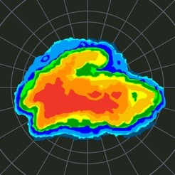
MyRadar NOAA Weather Radar
What it does: With a flick of the finger you can zoom into animated radars around your current location. The radar images are processed using a propriety software that processes raw data from the National Weather Service. Feels Like temperature, jet stream wind layering, a hurricane tracker, weather alerts and push notifications are available. You get a real-time or forecasted look at inclement weather to plan your trip or find out where to avoid storms. You can enable a number of layers that include animated real-time winds and temperature shading. Turn on the NWS Warning and MyRadar will push out alerts of dangerous weather.
What it costs: The app is free and you can pay for upgrades like the Hurricane Tracker ($2.99) and a professional radar pack ($6.99).
Where to find it: In the App Store for iOS devices or Google Play for Android devices.

American Red Cross
What it does: Provides life-saving instructions when you are in the middle of nowhere and need to render first aid to an accident victim. Learn, Prepare, Emergency, Test and More are the five tabs that provide instant access to any type of first aid emergency you might encounter. Videos are included in the step-by-step instructions for treatment and rendering first aid.
What it costs: The app and features are free.
Where to find it: In the App Store for iOS devices or Google Play for Android devices.
If you are using a screen reader and are having problems using this website, please call 1-800-227-7776 for assistance.
Copyright ©2026 TRACKER OFF ROAD®. All rights reserved.